Difference between revisions of "File:Map-ostrovets.jpg"
From Nuclear Heritage
Jump to navigationJump to search (This map shows the towns 50km around planned Ostrovets NPP in Belarus, including affacted {{WP|Vilnius}}, 40km away with population of 500.000, and two more Belarus towns ({{WP|Ašmiany}}, 15000, and {{WP|Smarhon}}, 36000 inhabitants) with dist...) |
|||
| Line 1: | Line 1: | ||
This map shows the towns 50km around planned [[Ostrovets NPP]] in [[Belarus]], including affacted {{WP|Vilnius}}, 40km away with population of 500.000, and two more Belarus towns ({{WP|Ašmiany}}, 15000, and {{WP|Smarhon}}, 36000 inhabitants) with distances below 30km. | This map shows the towns 50km around planned [[Ostrovets NPP]] in [[Belarus]], including affacted {{WP|Vilnius}}, 40km away with population of 500.000, and two more Belarus towns ({{WP|Ašmiany}}, 15000, and {{WP|Smarhon}}, 36000 inhabitants) with distances below 30km. | ||
| + | |||
| + | [[Category: Belarus]] | ||
Latest revision as of 04:59, 20 October 2013
This map shows the towns 50km around planned Ostrovets NPP in Belarus, including affacted Vilnius, 40km away with population of 500.000, and two more Belarus towns (Ašmiany, 15000, and Smarhon, 36000 inhabitants) with distances below 30km.
File history
Click on a date/time to view the file as it appeared at that time.
| Date/Time | Thumbnail | Dimensions | User | Comment | |
|---|---|---|---|---|---|
| current | 04:57, 20 October 2013 | 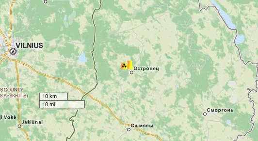 | 532 × 292 (37 KB) | Kardan (talk | contribs) | This map shows the towns 50km around planned Ostrovets NPP in Belarus, including affacted {{WP|Vilnius}}, 40km away with population of 500.000, and two more Belarus towns ({{WP|Ašmiany}}, 15000, and {{WP|Smarhon}}, 36000 inhabitants) with dist... |
You cannot overwrite this file.
File usage
The following page uses this file:
